Stenkrith Park Poetry Trail
This short but sweet walk around Stenkrith Park is packed full of exciting things to explore and see!
With stick dens, a waterfall, an enormous viaduct and a poetry trail….there’s plenty to keep little ones interested!
Stenkrith Park is a stunning little gem of a place on the edge of Kirkby Stephen.
The River Eden cuts through the middle of the park, beginning by coursing through the partially collapsed caves which form the legendary ‘Devils Grinding Mill’ (or Mustard Pot, dependant on what you read - pictured above). This is the name given to the churning water that is forced through narrow rocky channels and potholes that have been carved by rocky erosion underneath the impressive arches of one of the Eden Viaducts.
It is also the home of the Poetry Trail, a series of carved rocks positioned throughout the park. Each poem is reflective of the surrounding landscapes and there are plenty to spot along the way!
Oh, and there are stick dens. And geocaches. So… LET’S GO!
Walk Details for the Stenkrith Park Poetry Trail
Distance: 2 km (approximately 1.5 miles)
Terrain: Easy to follow and well walked paths. Some unnevenness underfoot and can be muddy in places. Mainly flat with little ascent/ descent. Not pushchair friendly.
Parking: The is a small car park next to the viaduct on Nateby Road.
Public Transport: Kirkby Stephen is within walking distance from the start of this walk and is serviced by buses from Stagecoach and Western Dales Bus.
Dog friendly? Yes, dogs to be kept on leads.
Location: Nateby Road, heading towards Nateby from Kirkby Stephen.
What 3 Words: eyelashes.chilled.hexes
Toilets/ Baby Change: None. Nearest is found in Kirkby Stephen.
Nearest Cafe/ Amenities: Kirkby Stephen.
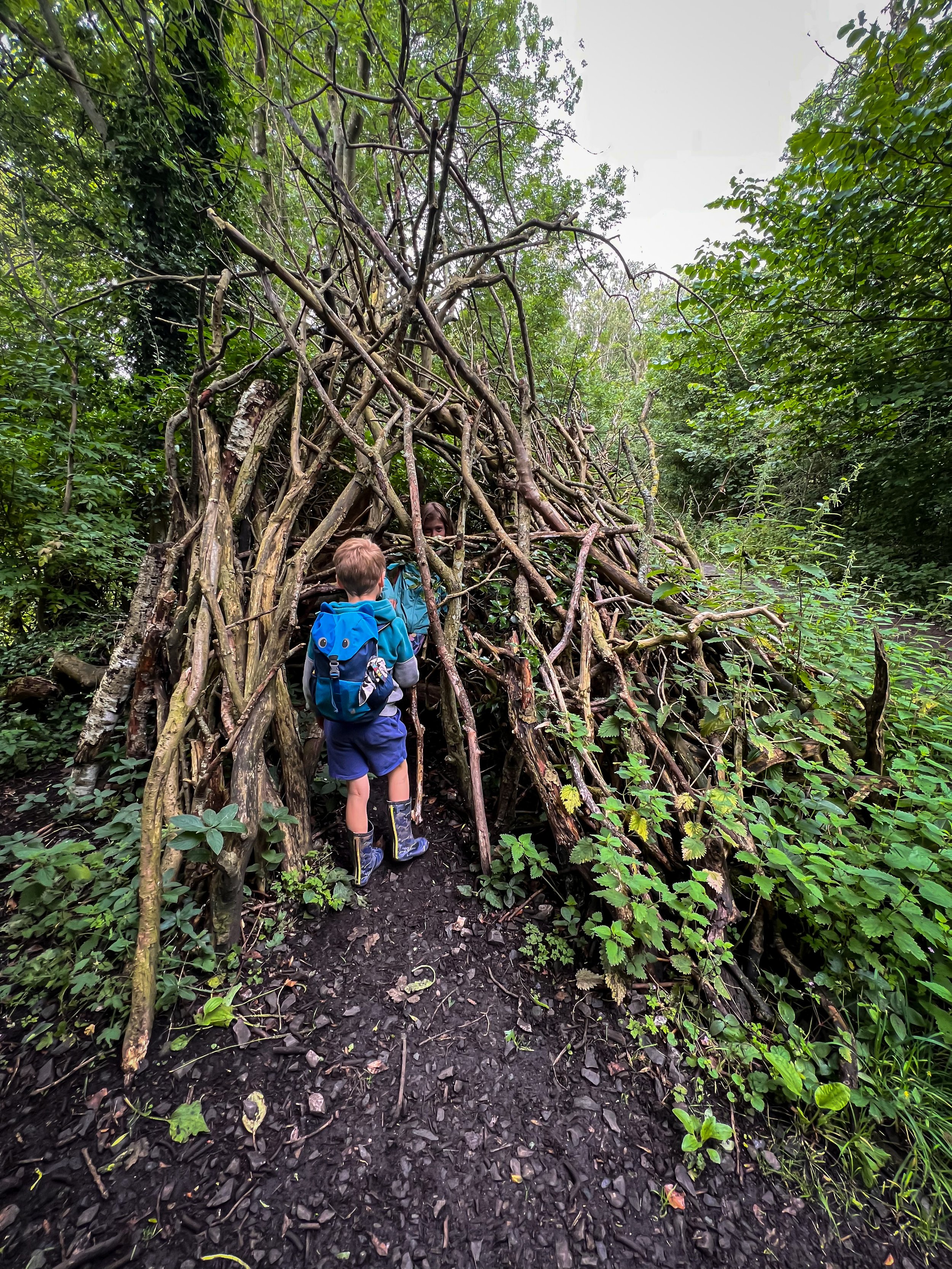
The large stick den that features at the start of the walk.
One of the pieces of poetry carved into the rock.
How to Walk the Poetry Trail
Directions (to be used in conjunction with a map)
Beginning from the car park at Stenkrith Bridge, head down the ramp out of the car park. The start of the ramp is indicated by a large information board. Follow the ramp downwards as it heads under the Viaduct and along the old railway line. The path here is wide and well surfaced and can be accessible by pushchair (although the entirety of the walk is not pushchair friendly)
Continue straight on with the River Eden on your left, here you will see a large stick den (pictured) and a few of the pieces of poetry too.
After around a third of a km, you will see a bridge over the old railway line. There is a path heading up the right hand side, through a gate at the top. On the other side of the gate you will see a waymarker for the Poetry Path. Turn left and head over the bridge.
After the bridge, the path turns into a wide walled track. Continue along there and follow it past more poetry carvings, until you are faced with a fork in the path. Here, there is a signpost pointing in the direction of Hartley and Nateby. You will be taking the left fork (not in the direction of either Hartley OR Nateby) but going through a wooden gate.
The path continues until it bends round to the left and crosses a footbridge over the Rive Eden. Cross the bridge and immediately turn left afterwards, continuing along the edge of the river. This will be on your left.
Continue to follow the path along the side of the river until you reach the viaduct again. Here, head up the steep bank, heading firstly right, then turn left to head over the Millennium footbridge that spans the river, providing you with a great view of the Devils Grinding Mill, which is even better when it’s been raining!
Then turn right and head back up the ramp to the car park.
Walked several times, most recently April 2024.
Above: The waymarker for the Poetry Path
Left: At the bottom of the Devil’s Grinding Mill in early Spring. You can see the Millennium Bridge footbridge above, with the viaduct behind.
The Kid Friendly Interesting Bits
✨ There is a geocache to find on this walk! Simply download the app to find out more!
👻 This walk has legend to go alongside it! The bizarre sounding waterfall on this walk is called the Devil’s Grinding Mill, Mustard Mill or Devil’s Hole for a reason (so legendary, they named it thrice) …. it’s because of the legends behind it. One such account is that the raging gorge was the unfortunate resting place of two lovers, who fell to their demise into the water. One version of this story is that the gentleman was call Deville and that he actually pushed his lover in, following her shortly after. The gorge has kept his name to this day.
The other version is that the sound of the rocks grinding against rock was in fact a portal to hell and that you could hear the sound of the Devil himself grinding his own personal supply of mustard. Wonder if he likes it in a ham sarnie….
What I do know, is that it is pretty spectacular after heavy rain and it’s definitely worth a stop even in drier weather, because then all of the arches and holes worn by the water and rock are visible!
🏰 Kirkby Stephen is only a short distance away where you can find cafes, and the play park.
💦 There are places to get down to the edge of the water to throw stones.
🌳 why not try one of our walking games? Or you can download a free scavenger sheet!
Want to grab the route?
Head to the Ordnance Survey Navigation App where you can download the route!
(Always carry a back up map and know how to use it)
Image is Copyright courtesy of Ordnance Survey
Helpful Information!
For more helpful information head to our safety tips and advice page.
⭐ We hope you enjoy our walks, but please exercise common sense as routes can change with the weather conditions and seasons! These walks are intended as a guide only and are undertaken at your own risk. The routes have been walked by our own two feet, but you know your own limits. If in doubt, turn back. Always take a back-up map, don’t rely on GPS or your phone alone, wear appropriate clothing for the weather and take adequate snacks and refreshments with you (although as a parent, I know you already know that bit!)
⭐ Leave no trace! Take nothing away and leave nothing behind, take all rubbish home with you.
⭐ If you choose to paddle, be aware of bio security. Always wear clean dry water shoes (if worn) to avoid cross contamination of species between watercourses, this is a particular issue in the Yorkshire Dales, to help protect the white clawed crayfish.
⭐ If you decide to paddle, be aware that wild water can be dangerous, and water levels will vary season to season. Always supervise children around water. Check out the safety information on the Royal Life Saving Society website.
More Westmorland Dales walks please?
I firmly believe that this stunning part of the world is the most underrated part of the Yorkshire Dales National Park!
With some of the most spectacular waterfalls and boasting some of the highest peaks, the Cumbrian side of the Yorkshire Dales is a place where you can fully immerse yourself in the dramatic and stark beauty of the fells.
And there are some reyt nice walks too!
Scroll using the arrows for all our Family Friendly Walks
Follow us for up to date Outdoors Adventures!
We live and BREATHE the Yorkshire Dales outdoors life!
BEEN INSPIRED? Tag us @reluctantexplorers
Come follow our journey over on Instagram, Facebook, Twitter and TikTok, where you’ll find up to date walk info, breaking news on Yorkshire Events, new Yorkshire Dales wild swim spots, climbing, caves and more!
Follow us on Social Media for all the up to date info: @thereluctantexplorers


