Burley in Wharfedale Stepping Stones
This classic Burley walk can be done either as a circular, or as a linear walk, or even as a pub walk to Askwith!
It is a great place for a bike ride, and it is now a fully pushchair friendly route too!
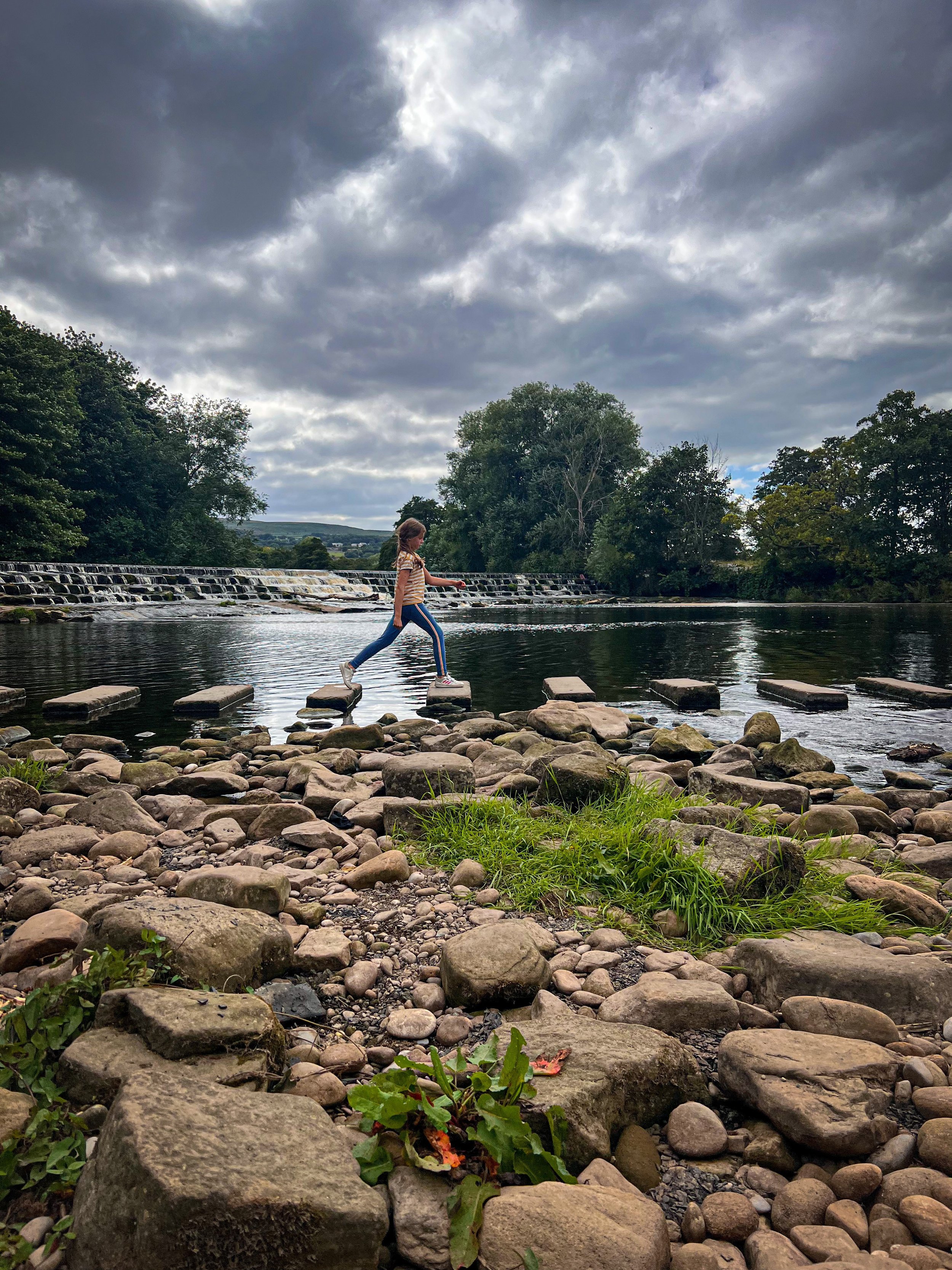
Are the Burley stepping stones passable…?
A classic commonly asked question in Burley in Wharfedale, as these stepping stones are often under water! However the good news is, is that it will not matter at all here! This walk gives you options and one of them means you don’t have to cross them at all! (We always love a walk with options when it comes to the kids!)
On this walk, you’ll find places to collect conkers, places to find geocaches and it starts and ends at the park! If you want to, you can also extend this walk to head to the newly refurbished Penny Bun pub in Askwith (but only if the stepping stones are passable….!)
Walk details for Burley in Wharfedale Stepping Stones
Distance: Short Route: 2 miles Longer Route to Askwith: 4.5 miles circular
Terrain: Concrete track, newly resurfaced path. The short version of this walk is pushchair friendly. Flat, little to no ascent. Some parts of this walk are on quiet residential roadways some parts can be muddy.
Parking: On street in Burley in Wharfedale near Grange Park. Please be courteous to its residents, comply with any parking regulations and do not block access routes or gateways. If you cannot find a spot to park, check out another of our Ilkley area walks.
Public Transport Links: Burley in Wharfedale. Less than 1km walk to the beginning of this route. The X84 also stops are Burley in Wharfedale.
Dog Friendly: Yes
Location: Burley in Wharfedale. Suggested start point, Grange Park, Grange Road.
Map: OS Explorer 297 Lower Wharfedale and Washburn Valley
What 3 Words: splendid.commented.heartache
Toilets/ Baby Change: No
Nearest Cafe/ Amenities: Burley in Wharfedale village centre for cafes, pubs and fish and chip shop. Askwith for the Penny Bun pub.
Sitting next to the weir when water levels are low in Summer
Directions to Burley Stepping Stones
Beginning from Grange Park Roundhouse facing the Red Lion Pub, turn right down Main Street (you will pass Burley Fisheries and The Queens Head pub on your right). Walk as far as the pedestrian crossing and cross the road. Turn right and and take an immediate left onto Iron Row.
Continue to walk down Iron Row, passing under the underpass, until you rise to Great Pasture Lane. Facing you at this point is the newly renovated Greenholme Mills. Iron Row was the route taken by the Mill workers in the village to work at the Mills in the late 18th/ Early 19th Century.
Turn left down Great Pasture Road and walk as far as the houses keeping the mill to your right (be wary of residents’ vehicles at this point). After approximately 200m, at the point where Great Pasture Road makes a sharp left there is a newly resurfaced path and wide metal gate to your right leading into the trees. Take that path.
In the trees, the track heads straight on joining a wide dirt track ahead. (There are geocaches to find here and conkers in early Autumn)
Follow the track, keeping the fields on your left and The Goit (mill ponds) on your right. After about 400m, the track begins to bend to the left and will lead you to the weir. A prominent wide track appears to your right, take this and head down to the river. You will be able to see the river ahead. This is the access point down to the stepping stones and to the stony shores of the Wharfe. ❗ The far banks of the River Wharfe are PRIVATE PROPERTY. Please be respectful to the landowners and stick to all permissive routes. As of July 2021 due to repeated instances of antisocial behaviour, the landowners have fenced off the far banks of the Wharfe. Only the permissive route is accessible and should be used.
Short Option (stepping stones submerged): After a good old fashioned stone throwing session, double back on yourself and turn right at the end of the short track you used to access the stepping stones. Here you need to turn right. Follow the wide track, which turns into an access road (Leather Bank) for the residents’ properties. Follow this for around 500m until you see the underpass which will lead you back to the village.
Take this underpass and walk until you reach Main Street, Burley in Wharfedale again. Turn left and walk back along the pavement into the centre of the village again, where you will see the Roundhouse, where you began.
Longer Route to Askwith, (crossing stepping stones): Cross the stepping stones to the far bank, where you need to keep left and head up the bank. The grassy path heads away from the river and through a gate. You will then pass through several fields heading gradually uphill, sticking to the public footpath and keeping the perimeter of the field roughly to your left. Along here there is a trail of geocaches to find along the way!
After passing through three gates, you will reach a large wooden five bar gate which is under trees. Head through that gate and then through a metal gate at the end and then turn left onto the road in Askwith. The pub is on your left.
If you don’t wish to go to the pub, at the metal gate, turn right onto the road and continue for a short distance. You will see a row of terraced houses to your left and a pubic bridleway sign next to the speed limit road sign on your right. Turn right here. There are more geocaches to find along here.
Continue along the track until you see some stables to your right. Just after these, there is a gate and a public bridleway sign head right through the gate following the signpost. Continue along the path until to go through another gate.
Turn left and head downhill through the field following the path, which largely sticks to the left perimeter, heading down and then right along the edge of the hedgerow (keeping that to your left). Then continue downhill to a stile and back to the stepping stones!
Skip to point 6. to complete your route!
Last walked July 2024.
Walking along the newly resurfaced path heading to the Goit.
The tree lined path back from Askwith to the stepping stones in Summer
What’s Cool for kids on this walk?
✨ There are a number of geocaches hidden along the route along The Goit from Great Pasture Road and then along through the fields to Askwith. If you have no idea what I’m talking about look them up. We call them ‘Treasure’ and they are a lot of fun to hunt down, download the app to find out more.
🌳 If you are trying to beat the whinge still, then why not check out our moan-busting walking games or nature activities?
🏬 Burley in Wharfedale boasts a number of family friendly pubs, a deli, cafes and a fish and chip shop, most of which are located near the start of this walk.
🧸 Burley in Wharfedale park is located in Grange Park, which is the suggested starting point for this walk (and is a great little incentive to get back for a play!).
💦 It is not advisable to paddle or swim on this walk due to the quality of the water at the stepping stones.
Helpful Information!
⭐ We hope you enjoy our walks, but please exercise common sense as routes can change with the weather conditions and seasons! The routes have been walked by our own two feet, but you know your own limits. Always take a back-up map, don’t rely on GPS alone, wear appropriate clothing for the weather and take adequate snacks and refreshments with you (although as a parent, I know you already know that bit!)
⭐ Leave no trace! Take nothing away and leave nothing behind, take all rubbish home with you.
⭐ If you choose to paddle, be aware of bio security. Always wear clean dry water shoes (if worn) to avoid cross contamination of species between watercourses, this is a particular issue in the Yorkshire Dales, to help protect the white clawed crayfish.
⭐ If you decide to paddle, be aware that wild water can be dangerous, and water levels will vary season to season. Always supervise children around water. Check out the safety information on the Royal Life Saving Society website.
Want to grab the route?
Head to the Ordnance Survey Navigation App where you can download the route!
(Always carry a back up map and know how to use it)
Image is Copyright of Ordnance Survey
Scroll using the arrows for all our Family Friendly Walks
Follow us for up to date Outdoors Adventures!
We live and BREATHE the Yorkshire Dales outdoors life!
Come follow our journey over on Instagram, Facebook, Twitter and TikTok, where you’ll find up to date walk info, breaking news on Yorkshire Events, new Yorkshire Dales wild swim spots, climbing, caves and more!
Follow us on Social Media for all the up to date info: @thereluctantexplorers


